Fence Disputes & How to Resolve Them
General Information for Property Owners in England & Wales
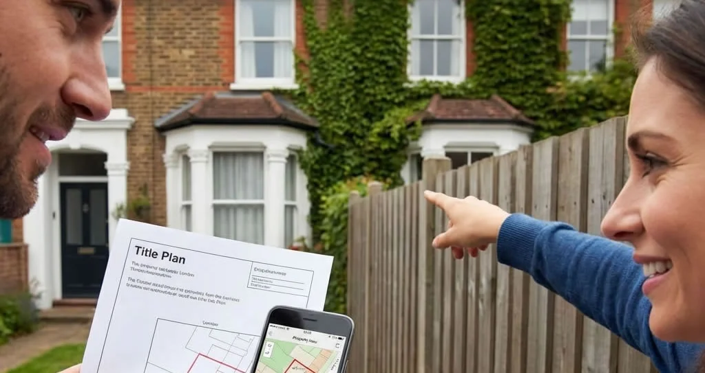
Most fence disputes with a neighbour can be resolved without going to court, but the right approach depends on the documents and facts of the specific property. This guide explains the general boundary distinction, common law presumptions, and practical next steps. It is general information only and not legal advice.
Most Fence Disputes Resolve Without Going to Court

Most disputes are resolved by comparing both title documents — before any professional is involved.
The large majority of boundary disputes between neighbours are resolved relatively quickly by obtaining the relevant title documents and conducting a straightforward comparison. As one leading boundary law reference confirms:
“Most situations requiring a house owner to seek out the property boundaries are quickly resolved by obtaining these two documents [the Title Register and Title Plan]. Rightly so, as these are the legal documents and must be referred to before all other documents.”
Although the title plan and register are not specifically designed to resolve disputes, most cases reveal sufficient detail for a clear conclusion. Those that require a closer look are usually resolvable using additional documents available from HM Land Registry. Very few end up in court — and those that do often result in significant regret given the exceptionally high legal costs involved.
Boundary litigation regularly costs £50,000–£150,000 per side and can take years to resolve. Courts expect both parties to have made genuine attempts to reach agreement before issuing proceedings. Start with the title documents — they cost a fraction of one hour of legal fees.
Legal Boundary vs Physical Boundary — The Key Distinction
Understanding this distinction is the foundation of all boundary work. The two are frequently confused, but they are fundamentally different things.
Invisible Line in the Title
- Recorded in Section A of the Title Register
- Shown approximately on the Title Plan (red edging)
- Defined by the Land Registration Act 2002 as a general boundary only
- Does not define the exact line on the ground
- Can be determined precisely only by formal HMLR application
Feature on the Ground
- The fence, wall, hedge, ditch, road or other visible feature
- Determined by physical inspection of the land
- Interpreted using common law presumptions where documents are silent
- May not precisely follow the legal boundary line
- Can be established by a chartered boundary surveyor
The legal boundary (from the title plan) and the physical boundary (the fence on the ground) are frequently not identical.
The legal boundary is described in the title register and illustrated in a general way on the Title Plan, where the extent of the registered land is edged in red. As noted in the Land Registration Act 2002, s.60, this edging shows only the general position of the boundary. The actual legal line could run along the inner face of a fence, through its centre, along its outer edge, or at a position not physically marked at all.
“The boundary of a registered estate as shown for the purposes of the register is a general boundary, unless shown as determined under this section. A general boundary does not determine the exact line of the boundary.” — Land Registration Act 2002, Section 60
Start With the Official Title Documents
The Title Register and Title Plan must be the first documents examined in any boundary issue.
Before inspecting the ground, examining old photographs, or instructing any professional, the title documents must be obtained and read. They are the primary legal record and inform everything that follows.
The Title Register
Described in Section A (Property Register), the title register provides a verbal description of the property. It will state the postal address, refer to the title plan, and may contain entries in the Charges Register describing boundary maintenance obligations or T-marks. Example Section A wording:
A: Property Register
SURREY : REIGATE AND BANSTEAD
1 (30.09.1980). The Freehold land shown edged with red on the plan of the above Title filed at the Registry and being 23 Cardington Road, Banstead (SM8 1JP).
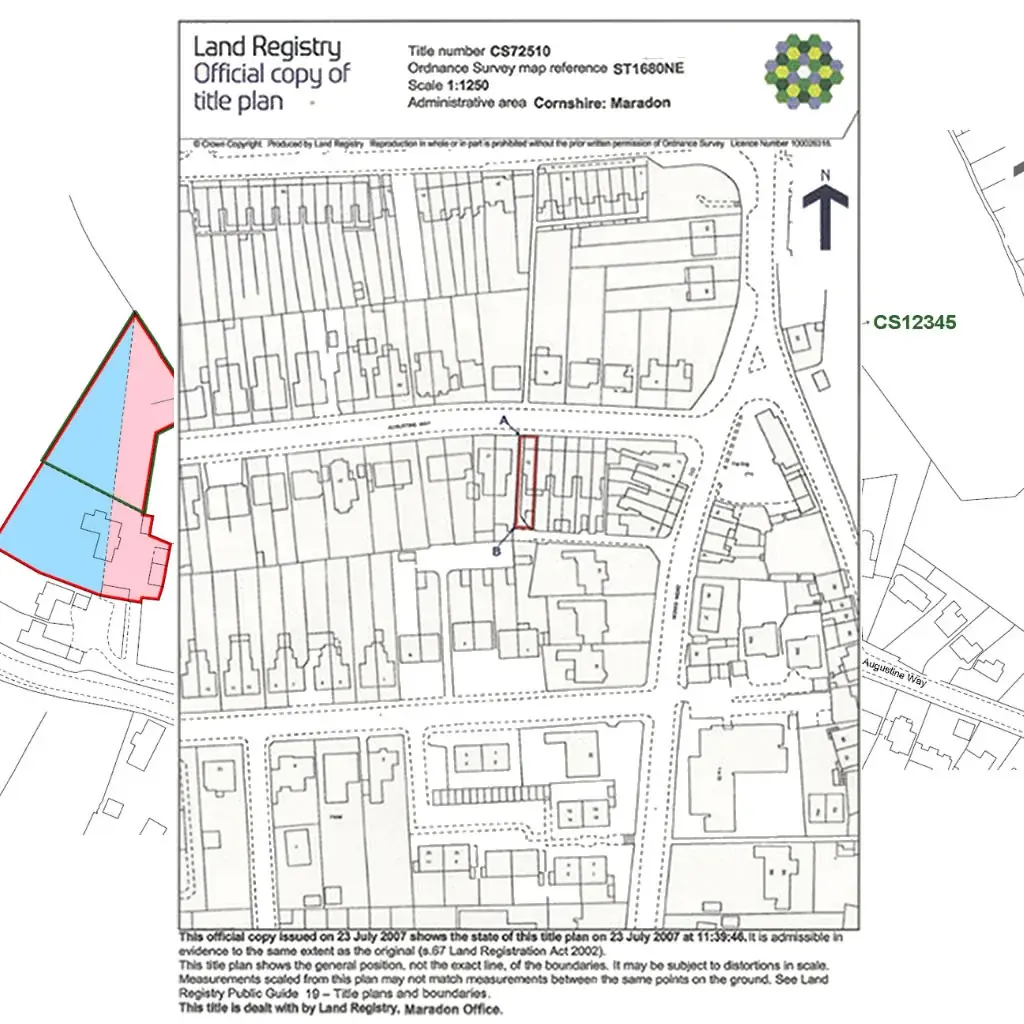
The Title Plan
The title plan shows the registered land edged in red on an Ordnance Survey base map. It is important to understand two key limitations:
- The red edging is plotted to the outside of the OS black edging. Both have an ink width that can represent several inches or more on the ground
- Ordnance Survey maps physical features as they exist at the time of survey — they do not determine property boundaries. Where there are no physical features, OS inserts no line; HMLR shows a dotted line to represent the general position
Implied Boundaries in the Register
Boundary information can also appear indirectly within quoted deed text in the register, but those references are clues rather than proof of the exact line. For example:
“Together with and subject to such rights of drainage as are now enjoyed in respect of the piece or parcel of land hereby conveyed but EXCEPT AND RESERVED under the Vendor a right of overhanging eaves in respect of the buildings standing on other property belonging to the Vendor and situate at the rear of the piece or parcel of land hereby conveyed.”
This type of entry implies that the legal boundary runs below the eaves of the adjoining property — significant where the eaves project over the disputed area. Always read all register entries carefully for such implications.
Get Your Official Title Documents
The Title Register and Title Plan are the essential first step for any boundary issue. Delivered instantly as PDF for any property in England & Wales.
Order Title Plan & Register → Order GPS Boundary Report →📍 Locate Your Registered General Boundary Before the Inspection
Understanding where the registered general boundary sits on the ground is the critical step between reading the title documents and walking the property. Our GPS Boundary Report plots the registered general boundary position using the HMLR INSPIRE cadastral dataset — so you can see where it sits relative to physical features before any conversation with your neighbour.
Find My Property & Order GPS Boundary Report →Conducting a Physical Boundary Inspection

A physical inspection uses the title plan as a reference guide while observing existing features on the ground.
Once the title documents have been reviewed, the next step is a physical inspection. This does not need to involve a professional at this stage — a systematic personal inspection, compared against the title plan, can reveal considerably more than the documents alone.
What to Look For
Boundary lines often, but not always, run in straight lines. Look for:
- Existing fences, walls or railings — note age, construction, post orientation
- Old fence lines — ghost posts, discolouration, concrete stubs in the ground
- Buried materials — wall footings, old bricks, stone courses below ground level
- Hedges — note which side the ditch is on, which side the roots are, and width
- Trees planted on the boundary — note trunk position relative to the line
- Ditches or streams — note their position relative to any hedge
- Road or pavement edging where it meets the plot
- Any join between a garden wall and the wall of a semi-detached house
Where a garden boundary is a shared wall that joins with the wall of a semi-detached house, the boundary is generally assumed to run through the centre of the wall. This is a common law presumption (see below) that applies in the absence of documentary evidence to the contrary.
It is strongly advisable to invite your neighbour to inspect alongside you and agree observations in writing. This avoids later disputes about what was found and is the fastest route to resolution without professional fees.
Types of Physical Boundary Feature

Boundaries take many forms. Each type has its own common law interpretation rules.
Fence Boundaries
The most common residential boundary type. Dealt with by examining T-marks in the title documents and the original conveyance deed plan. T-marks usually indicate maintenance responsibility for the fence or wall, not the exact legal boundary line itself. Note: there is no legal left-or-right rule and no legal significance to post orientation or arris rail position. See our complete fence ownership guide for detail.
Wall Boundaries
Where a shared wall divides properties, common law presumes the boundary runs through the centre of the wall unless documentary evidence states otherwise. Neither owner may demolish or materially alter the wall without the other’s agreement. The Party Wall etc. Act 1996 governs works to party walls and structures astride the boundary.
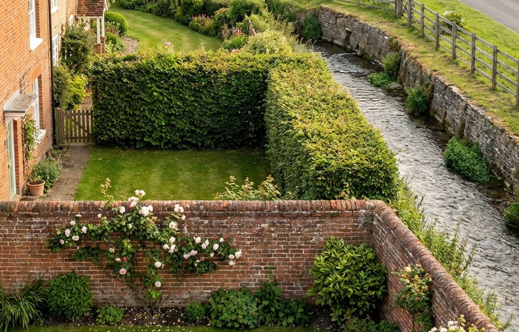
Hedge Boundaries
Hedges are often planted in the centre of the boundary and then grow wider over time. Where the hedge straddles the legal line, the boundary generally runs through its centre. Where a ditch accompanies the hedge, the hedge and ditch presumption applies — see our fence ownership landing page for the full explanation.
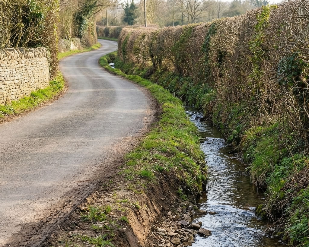
Ditch Boundaries
Under the hedge and ditch presumption (HMLR Practice Guide 40, §11.2), the legal boundary lies at the far (outer) edge of the ditch. The owner who dug the ditch did so at the edge of their land and piled the spoil inward — so the ditch lies entirely within their land.
Road Boundaries
Where a property fronts a highway, the boundary presumption is that the owner’s title extends to the centre line of the road, subject to the highway authority’s rights of use. This is known as the ad medium filum rule. It can be rebutted by the title documents, and does not apply where the road was adopted later.
Water / Stream Boundaries
Where a non-tidal stream or river forms the boundary, the presumption is that each riparian owner’s title extends to the centre of the watercourse (ad medium filum aquae). The owner is responsible for maintaining their half of the bank and the bed up to the centre. Note that this presumption applies to the bed of the stream, not the surface of the water. Where a watercourse changes course gradually over time, the boundary moves with it (accretion and diluvion). Where a sudden event such as a severe storm causes an abrupt change (avulsion), the boundary does not move — it remains at the pre-event centre line.
Boundary Trees
A tree growing entirely on one side of the boundary belongs to the landowner on whose land it grows. Where branches, roots, or fruit overhang the neighbouring land, the neighbour may cut them back to the boundary line but may not destroy the tree. Where the trunk straddles the legal boundary, English law treats the boundary as running through the centre of the trunk — and the tree is jointly owned. For the full analysis of straddle tree types, see our boundary trees section.
Common Law Boundary Presumptions

Common law presumptions give courts a default position where title documents are silent.
Common law presumptions are default rules built from High Court decisions. They apply where title documents are silent and can be relied upon unless there is evidence to the contrary in the title documents or deeds. Lower courts are bound to follow High Court decisions, making these presumptions highly predictable.
Legal boundary = far (outer) edge of the ditch. The owner dug the ditch at the extremity of their land and piled the spoil inward. Established in Vowles v Miller (1810); confirmed by the House of Lords in Alan Wibberley Building Ltd v Insley [1999]; further confirmed in Palmer v Upton [2015]. Rebuttable by title evidence.
Where a wall divides two properties, the boundary is presumed to run through the centre of the wall. Neither owner can remove or alter it without consent.
Owner’s title presumed to extend to the centre of an adjoining road, subject to the highway authority’s rights. Does not apply to adopted or motorway roads on all facts.
Each riparian owner owns to the centre of a non-tidal stream or river. Each is responsible for maintaining their half of the bed and banks.
Where a hedge straddles the boundary with no accompanying ditch, the boundary generally runs through the centre of the hedge. This presumption is weakened if the hedge has grown substantially to one side.
There is no common law presumption assigning fence ownership by left or right position, or by post/rail orientation. These are popular myths with no legal foundation.
“The Common Law of England and Wales comprises law built up from the judgments of decided cases in the higher courts. There are hundreds of cases relating to property boundaries and it is normally safe to rely on these presumptions unless there is evidence to the contrary.”
How to Resolve a Fence Dispute Without Litigation

A direct conversation with your neighbour, backed by the title documents, resolves the majority of disputes.
Get your Title Register and Title Plan
These are the primary legal documents. They must be examined before any other step. Available instantly as PDF from BoundaryFinder.
Ask your neighbour to get their documents too
Compare both title plans side by side. T-marks, boundary entries, and register wording may vary between the two titles and together provide the full picture.
Conduct a joint physical inspection
Walk the boundary together using the title plan as a reference. Note all physical features (old posts, buried bricks, hedges, ditches). Agree and record your joint observations in writing.
Apply the relevant common law presumptions
If the documents are silent and physical features are ambiguous, identify which presumption applies — hedge and ditch, wall centre, road centre — and explain your reasoning to your neighbour.
If agreement is reached — record it formally
A boundary agreement records a mutually agreed position and can be noted on both title registers by a solicitor — but it does not fix an exact legal line. For full legal certainty, a determined boundary application (Form DB) under Section 60(3) of the Land Registration Act 2002 converts the general boundary to a legally precise, registered line. A solicitor can advise which approach is proportionate to your situation.
If agreement is not reached — try mediation
A RICS-accredited boundary surveyor can prepare a joint expert report. Property mediation services are significantly cheaper than litigation and courts now expect parties to have attempted mediation.
Formal Routes If the Dispute Cannot Be Resolved
Where all attempts at direct resolution and mediation have failed, formal routes are available. These should be treated as a last resort given the costs involved.
HMLR Determined Boundary Application
Under Section 60(3) of the Land Registration Act 2002, the registered proprietor can apply to HM Land Registry to have the boundary determined with legal precision, converting it from a general boundary to a fixed one. Adjoining owners are notified and may object, and in some cases a written boundary agreement can support or simplify the application. HMLR will only determine the line if the evidence is sufficient. Once determined, the boundary is entered on the register as a determined boundary for that title.
First-tier Tribunal (Property Chamber)
The Land Registration division of the First-tier Tribunal hears boundary disputes arising from registered land. It is less expensive than the High Court but still involves significant costs. The tribunal will consider title documents, physical evidence, and expert surveyor reports.
High Court Proceedings
Reserved for complex cases, typically involving large areas of land or where significant financial interests are at stake. Costs regularly exceed £100,000 per party. The courts expect litigants to have explored all alternative resolution routes first.
Even “winning” a boundary dispute in court rarely results in full cost recovery. Both parties typically pay significant sums regardless of the outcome. The vast majority of boundary disputes relate to strips of land worth a fraction of the legal costs involved. Always seek legal advice about proportionality before issuing proceedings.
Where to Get Help with a Boundary Dispute
When you need support beyond the title documents, the following independent organisations and professionals specialise in resolving property boundary, fence, hedge and neighbour disputes across the UK. Bring your BoundaryFinder report, title plan and any historical maps — they provide strong supporting evidence.
Citizens Advice
Free, impartial guidance on boundary walls, fences, hedges and neighbour disputes — covering both legal rights and practical next steps.
GOV.UK — Resolving Neighbour Disputes
The official government step-by-step guide to resolving neighbour disputes, including when and how to involve a mediator or the council.
RICS Boundary Disputes Mediation Service
Specialist mediation for boundary and fence disputes run by the Royal Institution of Chartered Surveyors. Significantly cheaper than litigation and courts now expect parties to have attempted mediation before issuing proceedings.
Civil Mediation Council
The approved register of accredited civil and commercial mediators. Use the search tool to find a qualified mediator local to your property.
RICS — Find a Boundary Surveyor
Locate RICS-regulated firms that specialise in determining legal boundaries. A chartered boundary surveyor can prepare an expert report for mediation or the First-tier Tribunal.
Find a Property Solicitor
Legal advice is recommended if you need a formal Boundary Agreement, an HMLR Determined Boundary application, or a First-tier Tribunal application. Find a solicitor with property dispute experience.
Most boundary disputes are resolved without going to court through early advice or mediation. Once resolved, you can ask a solicitor to record the position formally with HM Land Registry where appropriate. Note that processes differ slightly in Scotland and Northern Ireland.
Information last reviewed: April 2026. This section provides general signposting only and is not a substitute for professional legal advice.
Fence Dispute Questions
A legal boundary is an invisible line recorded in the title register, shown approximately on the title plan. A physical fence boundary is the fence, wall, hedge, or ditch you can see on the ground. The two do not always coincide. Under Section 60 LRA 2002, the title plan shows only a general boundary — it does not define the exact ground position, which is why fence disputes are often more complicated than they first appear.
No. The title plan is a general boundary only. The red edging has a physical ink thickness that can represent several inches on the ground. For small disputed strips, the plan must be read alongside physical inspection and common law presumptions. It is the starting point, not the final word.
A boundary presumption is a default rule from Common Law — built up from High Court decisions — that establishes where a boundary lies in the absence of documentary evidence. Examples include the hedge and ditch presumption, the road centre-line presumption, and the party wall centre presumption. They are rebuttable by clear evidence in the title documents.
Not immediately. Obtain both title plans, conduct a physical inspection, and raise the issue with your neighbour directly. The majority of fence disputes settle at this stage without professional involvement. A solicitor becomes necessary if you need a formal boundary agreement, an HMLR determined boundary application, or if the dispute escalates to the First-tier Tribunal or court.
A RICS-chartered boundary surveyor prepares an expert report that combines documentary evidence (title plans, deed plans, Ordnance Survey history) with precise physical measurement of the boundary on the ground. Their report can be used in mediation or submitted to the First-tier Tribunal. Where both parties instruct the same surveyor (a “single joint expert”), costs are shared and the report carries greater weight.
A determined boundary is one that has been formally fixed with legal precision by HM Land Registry under Section 60(3) of the Land Registration Act 2002. Unlike a general boundary, it defines the exact line for that title. The proprietor applies, adjoining owners are notified, and HMLR will only determine the line if the evidence is sufficient. A written boundary agreement may help, but both neighbours do not have to sign the same application. It is more formal and harder to change than a general boundary record.
Most disputes are resolved by comparing both title documents — before any …

The legal boundary (from the title plan) and the physical boundary (the fe…
The Title Register and Title Plan must be the first documents examined in …

A physical inspection uses the title plan as a reference guide while obser…

Boundaries take many forms. Each type has its own common law interpretatio…
Common law presumptions give courts a default position where title documen…
A direct conversation with your neighbour, backed by the title documents, …