Where Is My Property Boundary?
Find the general boundary of your property in seconds. Enter your postcode, see your title outline on a satellite map, then walk to every corner point using GPS on your phone.
Instant PDF report — just £24.95
General boundaries — HM Land Registry INSPIRE Index Polygons · Section 60, Land Registration Act 2002
Find Property Boundaries — Then Walk Them
Under Section 60 of the Land Registration Act 2002, almost all registered property boundaries in England & Wales are general boundaries. We help you locate and walk yours.
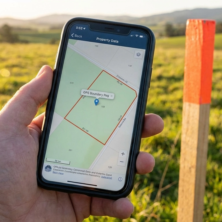
Boundary Map With Distances
Every boundary corner point mapped with distances between them. See the general shape and extent of your registered title on a clear satellite overlay.

See It on the Ground
Stand near your fence line and get a practical sense of where the general boundary sits in relation to the physical features on the ground.

Walk Your Entire Perimeter
Follow the GPS from corner to corner around your whole property. Compass bearings and distances guide you every step of the way.
Everything delivered instantly to your email — just £24.95:
Walk Your Boundaries With Your Phone
Our reports include mobile-friendly GPS guidance so you can walk the general position of your registered boundary point by point. Open the report on your phone and follow the compass bearing and distance to each corner — turning the registered line into something you can see and check on the ground.
Fence & Boundary Guides
Which Fence Is Mine?
Understand who owns which fence, how T-marks work, and what your title deeds actually say about your boundary.
Read the guide ›Fence Ownership Guide
A deep dive into T-marks, H-marks, and the legal rules that determine who owns and must maintain a boundary fence.
Read the guide ›Fencing Conventions
The long-standing building conventions that dictate which side of the boundary your fence sits on — and why.
Read the guide ›Fence Disputes Guide
97% of fence disputes are resolved without court. Step-by-step guide from direct conversation through to the First-tier Tribunal if needed.
Read the guide ›Historical Map Compare
Compare Victorian 1880s Ordnance Survey maps with modern mapping. See how your property boundaries have changed over 140 years.
Explore the map ›Historical Maps
Browse historical Ordnance Survey maps from multiple eras. Search by postcode to see how your area was mapped from the 1840s to the present day.
Explore the maps ›Historical Aerials
View 1940s–1960s RAF aerial photographs of your property. See original field boundaries, buildings and land use before modern development.
Explore the photos ›LiDAR Terrain Map
See the ground elevation, slopes and drainage ditches around any property boundary in England using free Environment Agency LiDAR data.
Explore the map ›General Boundaries
Land Registry title plans show general boundaries, not exact lines. Learn what this means for your property and why your fence may not sit on the legal boundary.
Read the guide ›HMLR Documents
Download your official HM Land Registry title plan and title register — the legal documents that show who owns your property and where the boundary lies.
Get title documents ›Where Are My T-Marks?
T-marks are missing from most modern title plans — but the obligation still binds you. Learn how to trace them from the original estate conveyance.
Read the guide ›Party Wall Act 1996
Building near a shared wall, boundary or neighbour’s land? Understand when the Party Wall Act applies, what notices to serve, and how to avoid a costly dispute.
Read the guide ›Party Wall Agreement
Need a party wall agreement before building work starts? Generate your Party Wall Notice and Consent Letter online — instant PDF, all 3 notice types covered.
Get your agreement ›Property Boundary Reports by City
GPS reports for every registered property in England and Wales. Find your city:
What Does BoundaryFinder Do?
BoundaryFinder is an authorised HM Land Registry data reseller. We help you visualise the general boundary of your property in England and Wales within seconds. Enter any postcode, select your property, and the tool uses the official INSPIRE Index Polygons — the same dataset published by HMLR — to show your registered title on a map with GPS coordinates for every corner point.
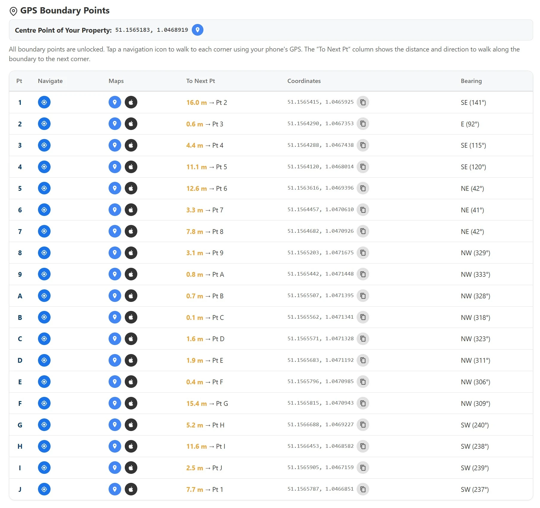
Each report gives you the GPS corner points displayed on an Ordnance Survey base map with distances and compass bearings between points. You can open the report on your phone and physically walk to each corner — turning the red line on your title plan into something you can see and check on the ground. Whether you need to understand your land for a fence discussion, home extension, or simple peace of mind, this is the practical starting point.
Important: All registered titles in England & Wales show general boundaries under Section 60 of the Land Registration Act 2002. The GPS corner points in this report are indicative — they show the approximate registered extent, not the exact legal boundary line. For full legal certainty, we strongly recommend obtaining the official HM Land Registry Title Plan and Title Register alongside this report.
Why Property Boundaries Matter
-
The General Boundary Rule
Your property boundary is one of the most legally significant lines associated with your home — yet most property owners have never seen exactly where it runs. In England and Wales, every registered title plan shows only a general boundary under Section 60 of the Land Registration Act 2002. The red edging on the HMLR title plan is accurate to within several inches at best, and at 1:1,250 scale a single millimetre of ink can represent over a foot on the ground.
-
Fence & Neighbour Disputes
That gap between the registered line and the physical fence causes most boundary disputes. When a neighbour builds close to the edge, when a fence is replaced in the wrong position, or when a garage extension crosses the registered line, the consequences can range from a difficult neighbour conversation to a formal First-tier Tribunal application. Understanding approximately which fence is yours — using GPS coordinates from official INSPIRE data as a practical guide — can help frame that conversation constructively.
-
Conveyancing & Pre-Exchange
Boundary evidence also matters at conveyancing. Buyers, solicitors and mortgage surveyors increasingly want to understand the general boundary before exchange. A GPS boundary report gives a practical visual overview quickly — but remember it shows general boundaries only. For a legally binding boundary determination or a formal pre-exchange check, the official HMLR title documents or a chartered boundary surveyor’s report remain the definitive reference.
GPS Boundary Reports
Every registered property in England & Wales has an INSPIRE Index Polygon on file at HMLR. A BoundaryFinder report converts that data into GPS coordinates for every general boundary corner of your registered title — plotted on an OS map and delivered as an instant PDF. Find the general boundary of your property and walk every corner with your phone.
Official Title Documents
The HMLR Title Plan and Title Register are the primary legal documents for any boundary or ownership question. The Title Plan shows the general boundary edged in red and any T-marks that indicate fence ownership in the UK. The Title Register contains the covenant wording from the original conveyance deed. Both are court-admissible Official Copies. Download title plans and title registers — instant PDF delivery.
Historical Boundary Evidence
Where a modern title plan is ambiguous, historical maps fill the gap. Compare your boundary on Victorian 1880s Ordnance Survey maps to see how boundary features like ditches, hedges and walls looked before post-war development changed them. For terrain-based evidence, the LiDAR terrain map reveals drainage ditches and embankments invisible on standard mapping — features that courts recognise as original field boundary markers.
Fence & Boundary Guides
Understanding your boundary starts with the legal framework. Our free guides cover every aspect: how to find out which fence is yours, the T-mark system explained, how to resolve a property boundary dispute without going to court, and the general boundaries rule that governs every title plan in England and Wales. Free resources for property owners, landlords and solicitors.
Find Your Property Boundaries Now
Enter your postcode to find property boundaries for any of the 26 million registered properties in England & Wales. See your boundary on a map in seconds.
Boundary Map With Distances
See It on the Ground
Walk Your Entire Perimeter
GPS Boundary Points Report
Find Your Property Boundary

Sample Boundary Report
