General Boundaries Explained
What the Red Line on Your Title Plan Really Means — England & Wales
Every registered title plan shows a general boundary only — not the exact legal line on the ground. Understanding this distinction is the foundation of all boundary law in England and Wales.
What Are General Boundaries?

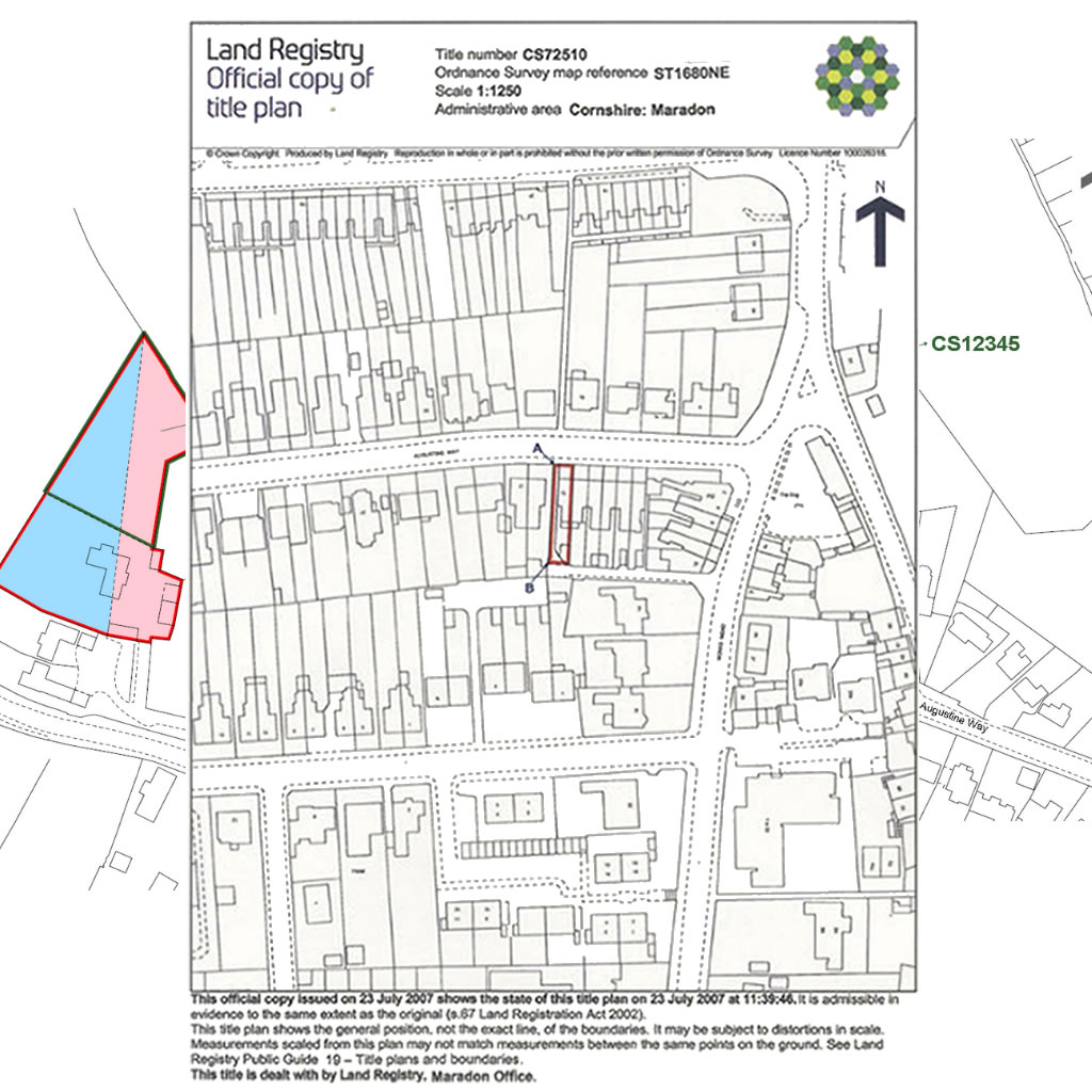
The red line on a title plan indicates the general boundary — not the exact legal position on the ground.
Every registered property in England and Wales has a title plan held by HM Land Registry. The red line drawn on that plan shows the extent of the registered title. That line shows only a general boundary — and for your property, that is almost certainly what it is.
There are approximately 26 million registered titles in England and Wales. Of those, only a tiny fraction have ever had a boundary formally determined.
Unless the register for your specific property explicitly states that a boundary has been determined under Section 60(3), your boundary is a general boundary. That applies to your property and to your neighbours’ properties too.
A general boundary indicates the approximate position of the boundary — it does not define the exact legal line on the ground. This principle is established by Section 60 of the Land Registration Act 2002:
“(1) The boundary of a registered estate as shown for the purposes of the register is a general boundary, unless shown as determined under this section.Read Section 60, Land Registration Act 2002 on legislation.gov.uk
(2) A general boundary does not determine the exact line of the boundary.” — Land Registration Act 2002, Section 60
This is not a new concept. Prior to the 2002 Act, Rule 278 of the Land Registration Act 1925 provided similar guidance, stating that “the filed plan or General Map shall be deemed to indicate the general boundaries only” and that “the exact line of the boundary will be left undetermined — as, for instance, whether it includes a hedge or wall and ditch, or runs along the centre of a wall or fence, or its inner or outer face.”
The red line on your title plan is a guide to the general extent of your property — not a definitive legal boundary. This is true of virtually every property in the UK. Determined boundaries, where the exact legal line has been formally fixed, are exceptionally rare — a tiny fraction of the 26 million registered titles in England and Wales. Your property almost certainly has a general boundary, and that is the normal, permanent legal position — not something that needs to be, or can easily be, changed.
Why Do General Boundaries Exist?

At 1:1,250 scale, a single millimetre of ink on the plan can represent several feet on the ground.
The general boundaries rule exists for practical reasons. HM Land Registry title plans are drawn on Ordnance Survey base maps at a scale of 1:1,250 (urban areas) or 1:2,500 (rural areas). At these scales, the red boundary line on the plan has a physical thickness that may represent several feet on the ground.
As noted by practitioners at Tanfield Chambers, “a millimetre’s difference either way may make a four-foot difference on the ground.” This inherent imprecision means the plan cannot be relied upon to determine the exact position of a boundary.
1 mm on the plan = 1.25 metres on the ground
1 mm on the plan = 2.5 metres on the ground
The ink line used to draw a boundary on a printed plan is itself typically 0.3–0.5 mm wide. At the urban scale, this means the line can represent an uncertainty of up to 60 cm — enough to determine whether a fence post sits on one property or another.
For this reason, registration guarantees title (that you are the registered owner) but does not guarantee the exact position of the boundary. These are legally distinct concepts.
How a Title Plan Boundary Is Created
Understanding why a general boundary is approximate requires understanding how it gets created. The process is largely manual and has not changed fundamentally since mass registration began.
Step 1 — The Deed Is Submitted
When a property is first registered, a solicitor submits the title deeds to HMLR. Those deeds may contain a written description (“along the north fence to the oak tree”), a hand-drawn plan, or measurements. For most residential properties registered before the 1990s, no GPS survey was ever conducted. The deed may be 50–100 years old.
Step 2 — A Mapping Officer Plots the Boundary
An HMLR mapping officer reads the deed and manually plots the boundary onto the OS MasterMap Topography Layer — the Ordnance Survey digital map used by HMLR as its reference grid. MasterMap captures physical features on the ground (walls, fences, buildings, roads, hedges) using GPS survey and aerial photogrammetry to approximately 0.1–0.5 m accuracy.
Where the deed describes a feature that exists in MasterMap — “the north wall of the garage” — the officer snaps the boundary line to that feature. The resulting coordinate is as accurate as the MasterMap feature: typically within half a metre.
Where the boundary runs through open ground with no physical feature to snap to — open garden, agricultural land, a hedge that was removed — the officer must interpolate from the scale of the deed plan. At 1:1,250, a 2 mm estimation error equals 2.5 metres on the ground.
Step 3 — The INSPIRE Polygon Is Generated
HMLR exports all registered title plan polygons as open data under the name INSPIRE Index Polygons. This is the dataset BoundaryFinder uses. INSPIRE polygons are not an independent survey — they are a digital export of the manually-plotted title plan boundaries. Their accuracy is a direct function of the mapping process described above.
The accuracy of a title plan boundary varies point by point within the same property. A vertex snapped to a MasterMap wall may be within 0.3 m. A vertex interpolated across open garden may be 1–3 m out. There is no metadata in the INSPIRE dataset to indicate which situation applies to any given point.
| Property type | Typical INSPIRE accuracy |
|---|---|
| Terrace or semi with solid walls on all sides | ±0.3–0.5 m |
| Suburban house, mixed fences and open garden | ±0.5–2 m |
| Rural plot with open boundaries | ±1–3 m |
| Old registration, features no longer present | ±2–5 m or more |
How Accurate Are BoundaryFinder’s GPS Coordinates?

BoundaryFinder GPS coordinates come directly from the HMLR INSPIRE Index Polygons dataset — a digital export of the registered title plan boundaries.
BoundaryFinder’s GPS coordinates are sourced directly from the HM Land Registry INSPIRE Index Polygons dataset. This is the official digital representation of the registered titles; our coordinates faithfully represent the source geometry using the OSTN15 NTv2 datum transformation.
The coordinates accurately represent the extent of the registered title as shown on the Land Registry plan. However, because the underlying plan is itself a general boundary, the coordinates share that characteristic — they are an accurate digital representation of an inherently general boundary.
Our GPS coordinates accurately locate every corner point of your registered title. Walking those points on the ground with a GPS device will show you where the title plan boundary is. What the coordinates cannot tell you is the exact legal boundary position, because that is a function of the general boundary rule — not of the data quality.
A professional surveyor using RTK (Real-Time Kinematic) GNSS equipment can locate the BoundaryFinder coordinates to centimetre accuracy on the ground. This places the general boundary line precisely, allowing you to assess any discrepancy between physical features (fences, walls, hedges) and the registered title extent. See our GNSS receiver guide for more on survey-grade accuracy.
When Is a Boundary Legally Precise?

Three routes exist to fix an exact legal boundary: a formal application to HMLR, a registered boundary agreement, or a court order.
A boundary becomes legally precise and ceases to be a “general boundary” only in limited circumstances:
- Determined boundary — An application has been made to HM Land Registry under the Land Registration Rules 2003 to have the exact boundary line determined and recorded in the register. This is relatively rare but is the gold standard for legal certainty.
- Boundary agreement — The adjoining landowners have entered into a formal boundary agreement, which has been registered against both titles. This is the most common route used in practice.
- Court determination — A court has determined the exact boundary line as part of a boundary dispute. The court order is then registered against both titles.
Unless one of these three applies, the boundaries shown on all registered title plans — and therefore BoundaryFinder’s GPS coordinates — are general boundaries.
Title plan shows approximate extent only. No exact legal position is recorded. The vast majority of properties.
Exact boundary line surveyed, submitted, and formally recorded in the register. Legally binding on both titles.
Case Law: The Scale of General Boundary Uncertainty

Boundary disputes often arise where the position of physical features does not match the general boundary shown on the title plan.
Courts have confirmed repeatedly that the area of uncertainty under the general boundaries rule can be far larger than people expect — particularly on rural land and large residential plots:
The Court of Appeal found that a strip of land amounting to over 1.5 acres fell within the general boundaries rule. Neither the title plan nor the physical features resolved the dispute definitively.
The boundary in dispute was approximately three-quarters of a mile long. The difference between the parties’ claims was 12 to 20 feet, resulting in about 5 acres of land with uncertain ownership despite both titles being registered.
The Court of Appeal reminded buyers not to rely solely on title plans and to conduct thorough boundary enquiries before purchase. A recent reminder that this issue affects modern transactions.
The court held that adjusting a general boundary “does not remove land from a title — it merely produces another general boundary in a more accurate position.” Such disputes are characterised as boundary disputes, not property disputes.
What Does This Mean for Property Owners?
For most practical purposes, the general boundary shown on the Land Registry plan is a reliable guide to the extent of your property. Physical features on the ground — fences, walls, hedgerows, ditches — often indicate the actual boundary, even if they do not precisely coincide with the red line on the plan.
However, if you are involved in a boundary dispute, planning an extension near a boundary, or buying a property where the boundaries are unclear, you should be aware that:
- The title plan is not a definitive boundary map
- The red line may not correspond exactly to features on the ground
- Registration guarantees title (ownership) but not the precise boundary line
- The physical fence, wall, or hedge may be the best evidence of the actual boundary
- Common law presumptions (e.g. hedge and ditch) apply where documents are silent — see our boundary disputes guide
- A professional surveyor with RTK equipment can locate GPS coordinates to centimetre accuracy on the ground
For the vast majority of property owners, the general boundary rule is a technical distinction that never becomes practically relevant. It matters most when:
- A neighbour disputes the exact position of a boundary
- Planning permission is required near a boundary
- A buyer or mortgage lender requires certainty about the exact extent of the title
- A boundary feature (fence, hedge, wall) has moved or is in poor condition
Getting a Determined Boundary

A RICS-chartered surveyor can prepare the plan and evidence required for a formal determined boundary application to HMLR.
If you need a legally precise boundary, you can apply to HM Land Registry for a determined boundary under Section 60(3) of the Land Registration Act 2002 and Rule 118 of the Land Registration Rules 2003.
The process involves four steps:
Commission a Survey
Instruct a RICS-chartered surveyor to produce a plan identifying the exact boundary line with precise coordinates. The plan must comply with HMLR’s requirements.
Submit Form DB
Submit Form DB to HM Land Registry with the surveyor’s plan and any supporting evidence (deeds, historic plans, expert reports).
Notify the Neighbour
HMLR requires you to notify the adjoining landowner, who has the right to object within a specified period. Agreement from both parties greatly simplifies the process.
Registration
If approved, the determined boundary is entered into the register and shown on the title plan, replacing the general boundary for that boundary feature.
The current fee for a determined boundary application is available on the HM Land Registry fee schedule.
Further Reading
- Land Registration Act 2002, Section 60 — the statutory provision
- Land Registration Rules 2003, Part 10 — rules on boundary determination
- HM Land Registry Practice Guide 40 — determined boundaries
- The General Boundaries Rule: Land Registry Plans — Tanfield Chambers
Get Your Property Boundary Report
GPS coordinates for every boundary corner point, satellite and street maps, and practical guidance for walking your boundary on the ground.
Search Your Property →General Boundaries — Common Questions
No. Under Section 60 of the Land Registration Act 2002, the red line shows only a general boundary — an approximation of the title extent. The ink line itself can represent feet of uncertainty on the ground at standard title plan scales of 1:1,250 or 1:2,500. The plan is a starting point, not a definitive boundary map.
No. Registration guarantees your title — that you are the registered owner — but it does not guarantee the exact position of the boundary line on the ground. These are legally distinct. The Land Registration Act 2002 is explicit: a general boundary does not determine the exact line.
Not necessarily. Because the title plan shows only a general boundary, a small discrepancy between the fence position and the red line is entirely normal. Physical features on the ground — particularly long-standing fences — are often the best evidence of where the actual boundary lies. If the discrepancy is large or disputed by a neighbour, professional advice is warranted.
A general boundary is the approximate boundary shown on a standard title plan — it applies to almost all registered land. A determined boundary is one that has been formally fixed by HMLR under Section 60(3) LRA 2002, with an exact line surveyed and recorded in the register. Determined boundaries are relatively rare but provide legal certainty. You can apply for one using Form DB.
Courts have confirmed it can be substantial. In Drake v Fripp [2011] EWCA Civ 1279, over 1.5 acres fell within general boundary uncertainty. In Well Barn Farming Ltd v Backhouse [2005], approximately 5 acres had uncertain ownership despite both titles being registered. The uncertainty scales with the size of the property and the scale of the plan used.
Yes — BoundaryFinder GPS coordinates come directly from the HM Land Registry INSPIRE Index Polygons dataset and faithfully represent the registered title extent as plotted by HMLR. However, the positional accuracy of any given boundary point depends on how it was originally mapped: a vertex snapped to a physical wall in OS MasterMap may be within 0.3–0.5 m of the true boundary; a vertex interpolated across open ground from an old deed may be 1–3 m out. A surveyor using RTK equipment can locate the coordinates to centimetre accuracy on the ground, but cannot recover accuracy that was never in the original mapping.
The red line on a title plan indicates the general boundary — not th…
At 1:1,250 scale, a single millimetre of ink on the plan can represent sev…
BoundaryFinder GPS coordinates come directly from the HMLR INSPIRE Index P…
Three routes exist to fix an exact legal boundary: a formal application to…

Boundary disputes often arise where the position of physical features does…
A RICS-chartered surveyor can prepare the plan and evidence required for a…