Get Your GPS Boundary Report — Two Reports Included — Just £24.95
Your purchase includes two detailed PDF reports delivered instantly to your email — a GPS Boundary Report with all 9 corner coordinates, a Terrain & Elevation Report, plus the Fence & Boundary Guide.
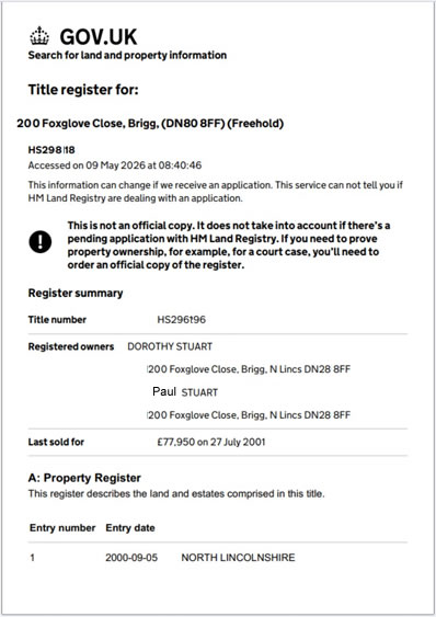
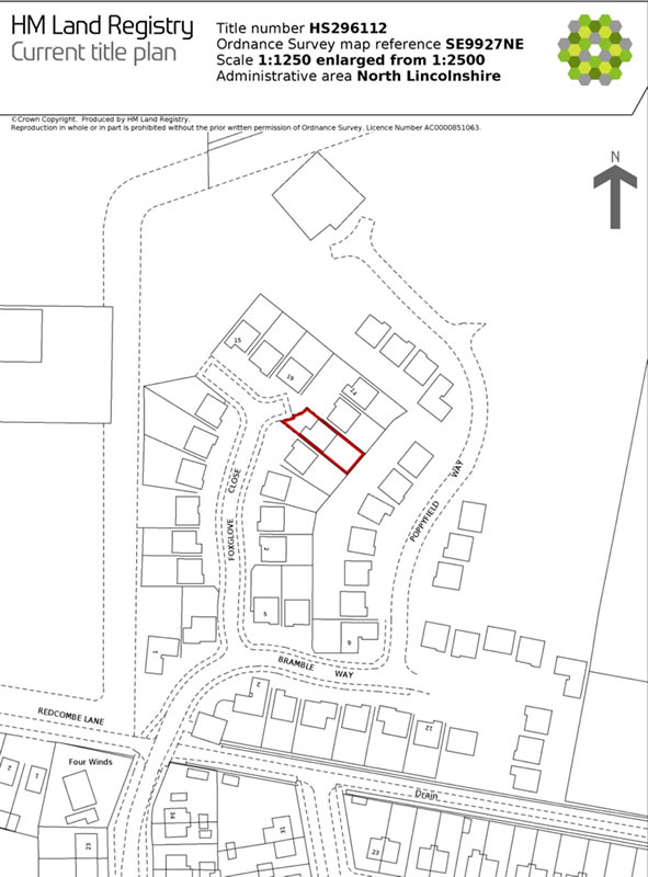
Official HMLR Title Documents — Essential Evidence for Any Boundary Issue
These are the official documents solicitors, surveyors and courts refer to when a boundary or fence ownership question arises. The Title Plan confirms the registered general boundary extent and any recorded T-marks. The Title Register confirms the legal owner and any fence maintenance obligations. Both are court-admissible Official Copies retrieved directly from HM Land Registry — and both complement your GPS Boundary Report: the report shows where your boundary sits on the ground; these documents show who owns it and what obligations apply.
Walk Your Boundary
✦ Unlocked with your report
Three ways to find your boundary on the ground Phone GPS Boundary File GNSS Receiver
Instant phone navigation — offline file for SW Maps or OsmAnd — or centimetre-accuracy GNSS receiver with RTK corrections.
.kmz SW Maps
Boundary polygon and all 9 numbered corners as a map layer. Best for walking the boundary on Android or iPhone.
.gpx OsmAnd & Garmin
Waypoints for every boundary corner — import into OsmAnd, Garmin Explore, or any GPX-compatible device or app.
Import guide
SW Maps (.kml): Move file to Internal storage/Android/media/np.com.softwel.swmaps/maps/kml/. Open SW Maps, tap Layers → Add Layer → Device Storage and select the file.
OsmAnd (.gpx): Menu → My Places → Tracks → Import. Garmin (.gpx): Import → Files.
Don’t have SW Maps? Download free: Google Play · App Store
Connect GNSS Receiver — RTK & NTRIP available
Boundary pegs and corner markers get buried over time — under decades of soil, hidden in undergrowth, or simply lost to memory. If you’ve walked your boundary and can’t find a physical mark, a GNSS receiver with RTK corrections lets you navigate to within a few centimetres of each general boundary point.
Navigate to each boundary corner on-site with a Bluetooth or USB GNSS receiver. Your live position appears as a blue dot on the boundary map — with real-time distance and direction to every corner.
- Live blue dot on the map — see exactly where you are relative to each corner
- Real-time distance and compass bearing to every corner, sorted nearest-first
- Optional RTK corrections via OS Net, rtk2go, or any NTRIP service for centimetre-level accuracy
- Works in desktop Chrome or Edge — no separate app required
Don’t have a GNSS receiver? We recommend the DataGNSS NANO Helix RTK →
Design & Planning Files
✦ Included free with your report
Professional digital files .dxf .geojson .csv
All 9 boundary corners. Import into free tools like QGIS, FreeCAD & LibreCAD — or paid tools like AutoCAD, SketchUp and ArcGIS.
.dxf AutoCAD & SketchUp
British National Grid (EPSG:27700) — scaled in metres. Drop straight into AutoCAD, SketchUp or planning software without unit conversion.
.geojson QGIS & ArcGIS
WGS84 (EPSG:4326) — import into QGIS, ArcGIS or any GIS platform for spatial analysis and overlay work.
.csv Spreadsheet
Every corner with Easting, Northing, Latitude & Longitude — open in Excel or Google Sheets, share with contractors.
Based on HM Land Registry INSPIRE Index Polygons — general boundaries under the Land Registration Act 2002. Consult a chartered surveyor for legally determined boundary lines.
General Boundaries
Under Section 60 of the Land Registration Act 2002, almost all registered boundaries in England & Wales are general boundaries — the same standard applies to every property. If you need a determined boundary for a legal opinion or dispute, consult a chartered surveyor →